원본 파일 (1,357 × 628 픽셀, 파일 크기: 20 KB, MIME 종류: image/png)

== 파일 설명 == sijn is kaulo koel en voeg zijn snap ( stijnsnoeck12)
| 설명 |
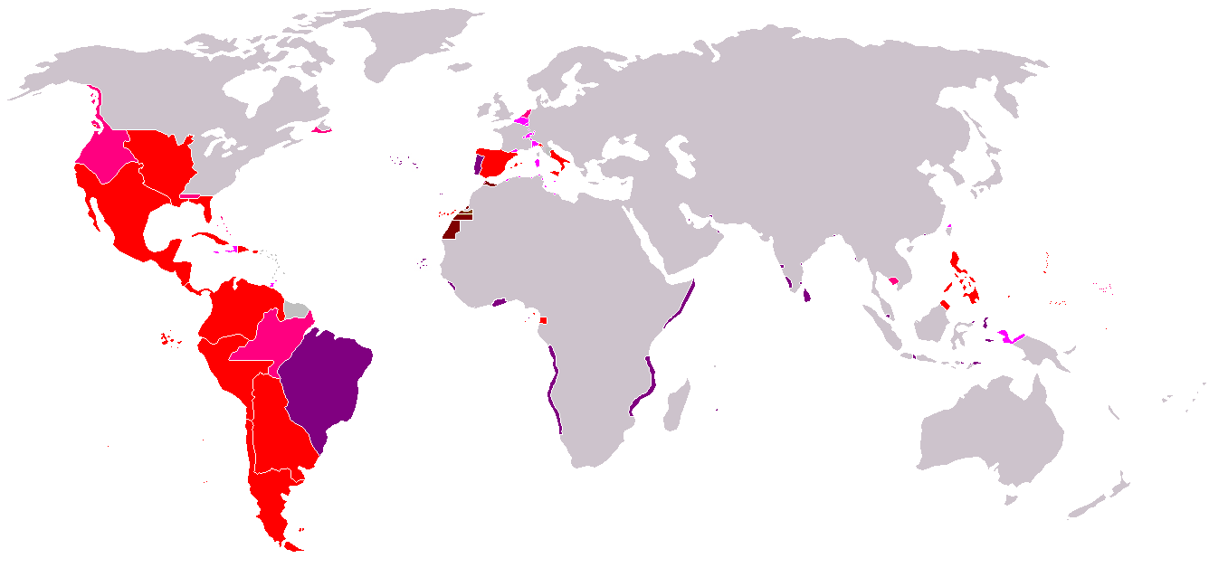
Map of the Spanish Empire from 295px. 파일 설명RedThe Spanish Empire as it stood under the en:House of Bourbon, reaching its peak in the early 1790s. Includes the en:Viceroyalty of New Spain, en:Viceroyalty of Peru, en:Viceroyalty of La Plata, en:Viceroyalty of New Granada, en:Audiencia of Chile, en:Cuba, en:Puerto Rico, en:Santo Domingo, the Louisiana colony, the Nootka colony, the en:Philippines, the satellite en:Kingdom of Naples and en:Duchy of Parma, and various island groups. Louisiana and New Orleans, which were never widely settled, were returned to France in 1800, the Nootka colony was abandoned in 1795; Spain ceded its claims to the en:Mississippi Territory to the United States in 1795 and en:Florida in 1819; en:New Spain became an independent en:Mexico in 1821. Spanish settlement did not reach the south of Argentina and Chile until the early en:19th century. By 1824, all of Spain's South American colonies had become independent republics. British economic rights in present-day en:Belize were established in the 18th century. The colony of en:British Honduras was not created until 1841, after the end of Spanish rule in the region. Most of Central America became independent in 1823 as the en:United Provinces of Central America. Cuba was granted independence and Puerto Rico was ceded to the United States after the en:Spanish-American War. PinkRegions of Spanish influence over various periods; disputed (i.e. Pacific Coast), unrecognized (i.e. en:Dutch Republic), or short-lived claims (i.e. Cambodia).
LavenderTerritories lost at or before the en:Peace of Utrecht in 1714. Spain lost Jamaica to England in the 1650s and Haiti to France in the en:17th century. Many smaller islands in the en:Bahamas and the en:Lesser Antilles were also settled by other Europeans during this period. Spain's territories in present-day France, such as en:Rousillon and the en:Franche-Comté, were conquered Louis XIV. Spain was stripped of her remaining European dominions in 1714. Spain reconquered some of her lost Italian possessions from the Austrians in the 18th century, placing Bourbon princes on the thrones of Parma, Naples, and Sicily. However, these were not incorporated again into the Spanish Crown. PurplePortuguese possessions ruled jointly under the Spanish sovereign, 1580-1640. Brown |
| 날짜 | Commons upload by Kjetil r 10:47, 14 May 2006 (UTC) |
| 출처 |
Originally from en.wikipedia; description page is (was) here
|
| 저자 | Users Albrecht, Arthur Wellesley, XGustaX on en.wikipedia |
| 저작권 (이 파일을 인용하기) |
GFDL |
라이선스

|
GNU 자유 문서 사용 허가서 1.2판 또는 자유 소프트웨어 재단에서 발행한 이후 판의 규정에 따라 본 문서를 복제하거나 개작 및 배포할 수 있습니다. 본 문서에는 변경 불가 부분이 없으며, 앞 표지 구절과 뒷 표지 구절도 없습니다. 본 사용 허가서의 전체 내용은 GNU 자유 문서 사용 허가서 부분에 포함되어 있습니다. |
| 이 파일은 크리에이티브 커먼즈 저작자표시-동일조건변경허락 3.0 Unported 라이선스로 배포됩니다. | ||
| ||
| 이 라이선스 틀은 GFDL 라이선스 변경의 일부로 이 파일에 추가되었습니다. |
See also


파일 역사
날짜/시간 링크를 클릭하면 해당 시간의 파일을 볼 수 있습니다.
| 날짜/시간 | 섬네일 | 크기 | 사용자 | 설명 | |
|---|---|---|---|---|---|
| 현재 | 2024년 6월 6일 (목) 20:24 | | 1,357 × 628 (20 KB) | wikimediacommons>Janitoalevic | Improved borders |
이 파일을 사용하는 문서
이 파일을 사용하는 문서가 없습니다.