
원본 파일 (640 × 640 픽셀, 파일 크기: 138 KB, MIME 종류: image/jpeg)
파일 설명
| 설명 |
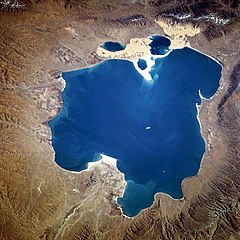
Deutsch: Qinghai-See, China - November 1994
English: Qinghai Lake, China - also, originally known as Koko Nor in Mongolian and Tso Ngonpo in Tibetan - November 1994
Español: Lago Qinghai, China - Noviembre 1994
中文:青海湖 |
|||||
| 날짜 | 촬영 날짜: 1994년 11월 8일, 04:13:36 GMT | |||||
| 출처 |
https://eol.jsc.nasa.gov/sseop/EFS/photoinfo.pl?PHOTO=STS066-118-23 https://eol.jsc.nasa.gov/SearchPhotos/photo.pl?mission=STS066&roll=118&frame=23 |
|||||
| 저자 | NASA | |||||
| 저작권 (이 파일을 인용하기) |
|
|||||
| NASA information |
|

| 카메라 위치 | | 이 지역의 다른 사진을 보기: OpenStreetMap |
|---|
This image or video was catalogued by one of the centers of the United States National Aeronautics and Space Administration (NASA) under Photo ID: STS066-118-23. This tag does not indicate the copyright status of the attached work. A normal copyright tag is still required. See Commons:Licensing. Other languages:
|
파일 역사
날짜/시간 링크를 클릭하면 해당 시간의 파일을 볼 수 있습니다.
| 날짜/시간 | 섬네일 | 크기 | 사용자 | 설명 | |
|---|---|---|---|---|---|
| 현재 | 2005년 10월 11일 (화) 00:02 | | 640 × 640 (138 KB) | wikimediacommons>Immanuel Giel | Qinghai Lake, China - November 1994 '''Source''': from the English Wikipedia<br> image description [http://eol.jsc.nasa.gov/sseop/EFS/photoinfo.pl?PHOTO=STS066-118-23 here] en:Qinghai Lake {{PD-USGov-NASA}} |
이 파일을 사용하는 문서
다음 문서 1개가 이 파일을 사용하고 있습니다: