미리 보기 크기: 800 × 352 픽셀 다른 해상도: 320 × 141 픽셀 | 640 × 282 픽셀 | 1,427 × 628 픽셀
원본 파일 (1,427 × 628 픽셀, 파일 크기: 37 KB, MIME 종류: image/png)
파일 설명
| 설명 |
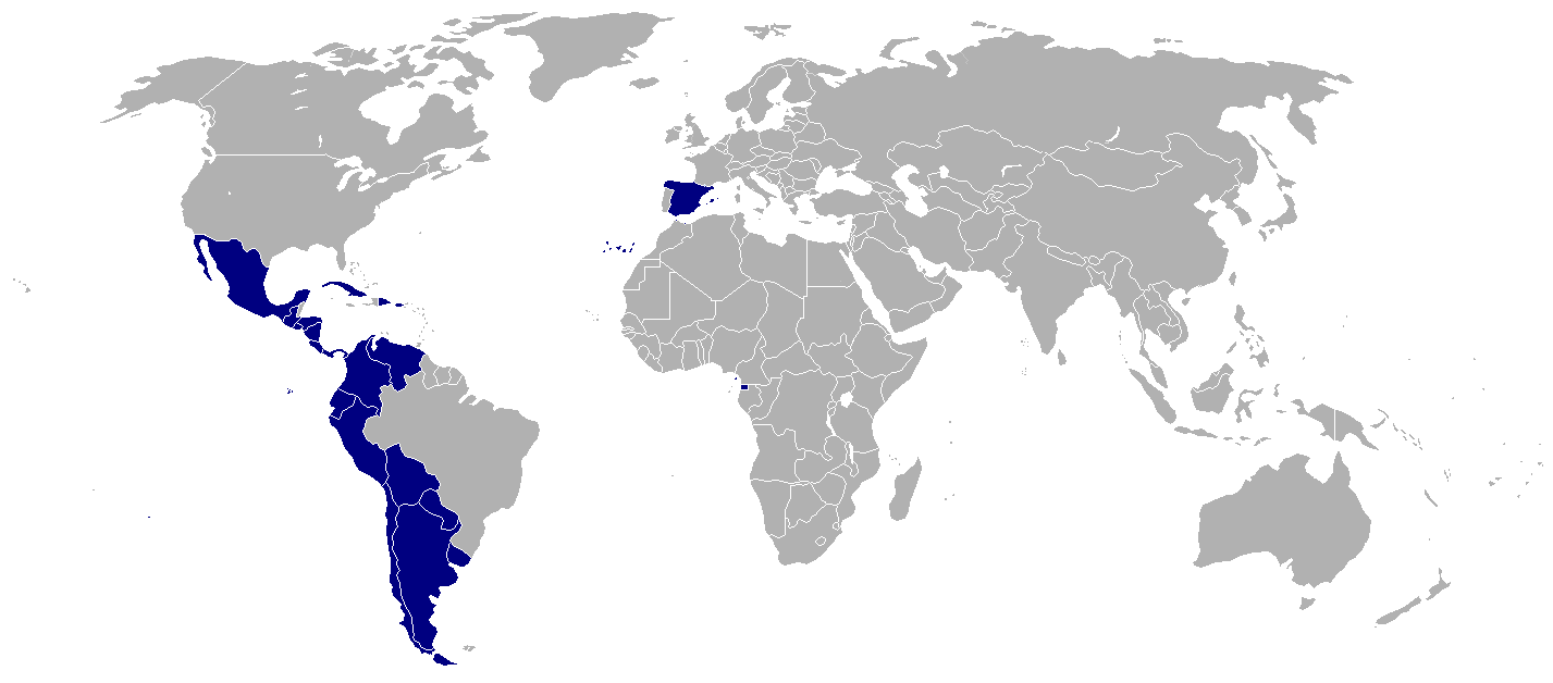
English: This map shows the countries that are traditonally considered as the core of the Hispanidad (because they have Spanish as official language and it is the main language of the country, or because they have been historically important in the creation of the Hispanophone). Note that this is not the same as the Hispanophone map, which shows all the parts of the World where Spanish or its créole languages are spoken. |
|||
| 날짜 | ||||
| 출처 | 자작 | |||
| 저자 | Onofre Bouvila | |||
| 다른 버전 |
|


Legend
|
Països considerats tradicionalment com el nucli de la Hispanitat.
NOTA: Per a veure la llista detallada dels països que apareixen al mapa, vegi's la seva pàgina de descripcció |
|
Países considerados tradicionalmente como el núcleo de la Hispanidad.
NOTA: Para ver la lista detallada de los países que aparecen en el mapa, véase su página de descripcción |
|
Countries traditionally considered as the core of the Hispanidad.
NOTE: For a detailed list of the countries that appear in the map, see its description page |
|
Pays considérées traditionnellement considérés comme le noyau de la Hispanité.
NOTE: Pour obtenir la liste détaillée des pays qui apparaissent dans la carte, voir sa page de description |
List of countries
Català Castellano English Français Europa Europa Europe Europe  Espanya España Spain Espagne
Àsia i Oceania Asia y Oceanía Asia and Oceania Asie et Océanie  Filipines Filipinas Philippines Philippines
Àfrica África Africa Afrique  Guinea Equatorial Guinea Ecuatorial Equatorial Guinea Guinée Equatoriale
Amèrica América America Amérique  Argentina Argentina Argentina Argentine
 Bolívia Bolivia Bolivia Bolivie
 Xile Chile Chile Chili
 Colòmbia Colombia Colombia Colombie
 Costa Rica Costa Rica Costa Rica Costa Rica
 Cuba Cuba Cuba Cuba
 Equador Ecuador Ecuador Équateur
 El Salvador El Salvador El Salvador El Salvador
 Guatemala Guatemala Guatemala Guatemala
 Honduras Honduras Honduras Honduras
 Mèxic México Mexico Méxique
 Nicaragua Nicaragua Nicaragua Nicaragua
 Panamà Panamá Panama Panamá
 Paraguai Paraguay Paraguay Paraguay
 Perú Perú Peru Pérou
 Puerto Rico Puerto Rico Puerto Rico Porto Rico
 República Dominicana República Dominicana Dominican Republic République Dominicaine
 Uruguai Uruguay Uruguay Uruguay
 Veneçuela Venezuela Venezuela Venezuela
라이선스
| 이 작품은 저작자인 Onofre_Bouvila에 의해 퍼블릭 도메인으로 공개된 작품입니다. 이 공개 선언은 전 세계적으로 유효합니다. 만약 저작권의 포기가 법률적으로 가능하지 않은 경우, |
파일 역사
날짜/시간 링크를 클릭하면 해당 시간의 파일을 볼 수 있습니다.
| 날짜/시간 | 섬네일 | 크기 | 사용자 | 설명 | |
|---|---|---|---|---|---|
| 현재 | 2020년 7월 18일 (토) 16:06 | | 1,427 × 628 (37 KB) | wikimediacommons>Maphobbyist | Not official |
이 파일을 사용하는 문서
다음 문서 1개가 이 파일을 사용하고 있습니다: